


From staff reports
BIRMINGHAM — The National Weather Service in Birmingham has issued a winter storm watch for much of north central Alabama, including Jefferson and St. Clair counties. The watch will be in effect from late Sunday evening until Monday evening.
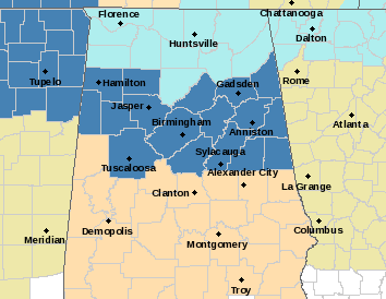
According to the NWS, a strong storm system will move into central Alabama beginning Sunday night after midnight.
The system could produce ice accumulations between one tenth of an inch and three tenths of an inch in some areas.
Temperatures will be well below freezing as the system moves into Alabama, producing areas of freezing rain, snow and sleet across a good portion of the watch zone through Tuesday.
The two-wave system could turn to all rain Monday night before exiting as snow by Tuesday afternoon. The NWS warns the watch area could be extended in time and area as the system draws nearer.
Watch Tribune meteorologist Dennis Washington’s forecast below.


