


From The Trussville Tribune staff reports
BIRMINGHAM — UPDATED: The National Weather Service in Birmingham issued a hazardous weather outlook at 4 a.m. on Monday for central Alabama, including Jefferson, St. Clair and Blount counties.
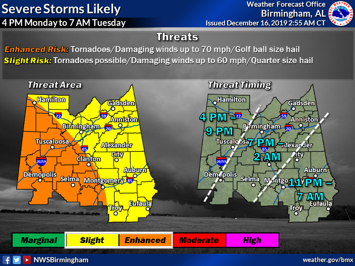
“There is a risk of severe storms for all of central Alabama from roughly 4 p.m. this afternoon until 7 a.m. Tuesday. Tornadoes, damaging straight line winds and golf ball size hail will all be possible.”
A weather system producing possible severe thunderstorms, large hail and tornadoes will pass through the local area Monday with the highest risk coming between 7 p.m. Monday and 2 a.m. Tuesday, according to the National Weather Service in Birmingham.
Light showers may occur during the day, but heavier activity is expected Monday afternoon through Tuesday morning when severe storms are possible. A few tornadoes and damaging winds appear to be the main threats, but isolated large hail is also possible, NWS said in a statement Sunday night.
Monday- A slight chance of showers, then a chance of showers and thunderstorms after noon. Cloudy, with a high near 69. South wind 10 to 15 mph. Chance of precipitation is 40%.
Monday Night- Showers and thunderstorms before 3 a.m., then showers and possibly a thunderstorm after 3 a.m.. Some of the storms could be severe. Low around 43. South wind 10 to 15 mph becoming northwest after midnight. Chance of precipitation is 100%. New rainfall amounts between 1 and 2 inches possible.
Tuesday- A 20% chance of showers before 9 a.m. Cloudy, with a temperature rising to near 51 by 10 a.m., then falling to around 43 during the remainder of the day. Northwest wind 10 to 15 mph.


