From The Tribune staff reports
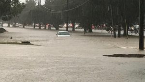
BIRMINGHAM — The threat for flash flooding will continue across the Southeast less than a week after


“Showers and thunderstorms, that could be heavy at times over the Southeast will be in the region in the coming days, but anywhere that does see these storms will have a continued flooding risk that could cause travel delays and localized flooding,” AccuWeather senior meteorologist Alan Reppert said.
Several locations across the South have already picked up their fair share of rainfall since September 1, leaving them waterlogged. New Orleans reported over 7 inches of rain since Sept. 1, which is nearly 200 percent of the normal rainfall for this time period. Mobile, Alabama, is another city that has been left waterlogged since Sept. 1, where 209 percent of the normal rainfall has fallen.
With more rain on the horizon, many cities in the South will remain on alert for the continued threat of localized flash flooding through Tuesday in the Mississippi River Valley and farther east through Wednesday.
“These storms will be drenching at times as they will have moisture from the Gulf of Mexico and Atlantic to work with, leading to the continued threat of localized flash flooding,” Reppert explained.


