


From Tribune staff reports
BIRMINGHAM — If you don’t like the weather in the Tribune area, just give it a minute. The rollercoaster continues with a warming trend on Sunday and Monday with temps in the 40s and 50s, respectively. Tuesday will bring temperatures in the 60s and five straight days of rain.
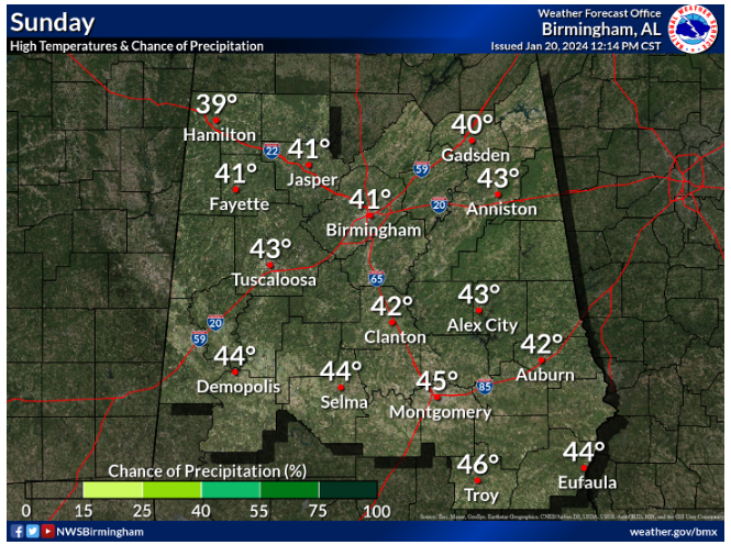 According to the National Weather Service in Birmingham, today will bring sunshine with a high near 41. East wind 5 to 10 mph. Tonight will be mostly clear, with a low around 24. East wind around 5 mph becoming calm in the evening.
Monday will see Increasing clouds, with a high near 52. Southeast wind 5 to 10 mph. By Monday night, rain chances move in with a 20 percent chance of showers after midnight. Mostly cloudy, with a low around 40. Southeast wind around 10 mph.
On Tuesday, there is a 30 percent chance of showers. Mostly cloudy, with a high near 60. Southeast wind 10 to 15 mph. Showers are likely on Tuesday night, mainly after midnight. Mostly cloudy, with a low around 53. Chance of precipitation is 60%.
Rain continues on Wednesday with showers and possibly a thunderstorm. High near 66. Chance of precipitation is 80%. Wednesday night is more of the same with showers and possibly a thunderstorm. Low around 61. Chance of precipitation is 90%.
Thursday brings more of the same with showers and possibly a thunderstorm. High near 68. Chance of precipitation is 90%. Showers are likely Thursday night and possibly a thunderstorm before midnight, then a chance of showers and thunderstorms after midnight. Mostly cloudy, with a low around 55. Chance of precipitation is 60%.
Highs Friday and Saturday will be in the mid-60s with a 40 percent chance of rain both days.


