Some big changes are coming to northeast Jefferson County during the next 48 hours.
[WATCH my weather forecast here.]
Tonight and Friday Morning
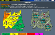
A cold front is approaching the state today, bringing with it a lot of rain and thunderstorms. A few thunderstorms could develop across the area this afternoon, but most of us will not get wet until after midnight when a line of thunderstorms will move through our area.
The best chance of getting wet will happen between midnight tonight and noon Friday. During that time frame, rain chances are around 80 percent. Thunderstorms are very possible, and a few of these thunderstorms could produce hail, frequent lightning, and gusty winds. The risk of severe weather with this system is low, but possible.
Friday Afternoon and Friday Night
The rain comes to an end by early Friday afternoon, followed by clearing skies and MUCH colder air. Temperatures will begin to fall Friday afternoon, bottoming out around 48 degrees Saturday morning.
Saturday and Sunday
The weekend will be chilly, but sunny. Expect clear, blue skies both Saturday and Sunday. Temperatures Saturday will struggle to reach 68 degrees and will fall to around 44 degrees Sunday morning. Sunday’s high will be up near 70 degrees.
Severe Weather Updates
Follow me on Twitter @stormhug and The Trussville Tribune @TrussTribune for updates on the weather situation tonight and Friday morning as conditions warrant.