


From The Trussville Tribune staff reports
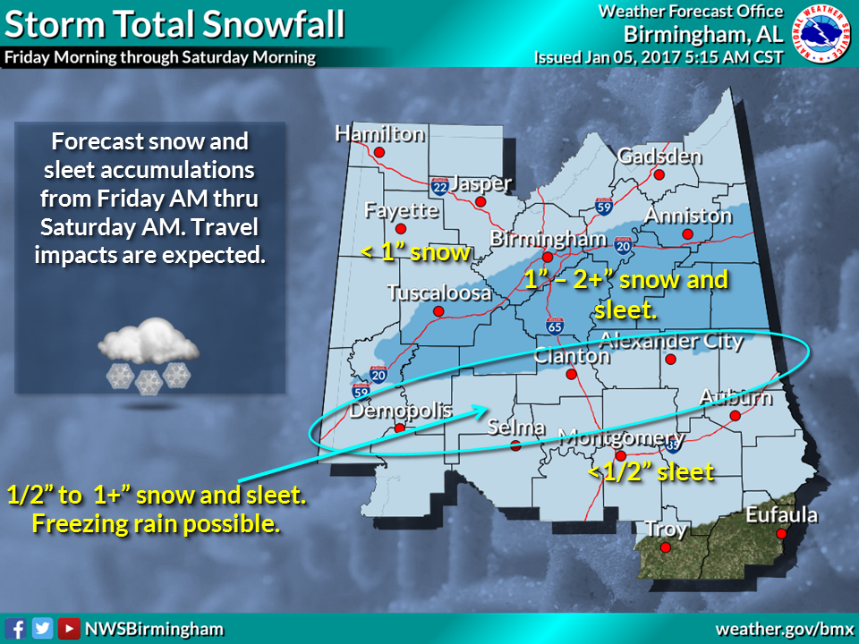
UPDATED INFORMATION- As of 5 a.m. Thursday, the NWS in Birmingham has expanded the winter storm watch area and shifted the impact area slightly. The local forecast suggest snow will begin the fall in the northern part of Alabama after 1 a.m. on Friday.
Graphic via NWS Birmingham
Graphic via AlabamaWX.com
The newest model indicates the largest impacts will be along and south of the I-20 corridor. Models suggest 2 to 3 inches of snow in the corridor from Tuscaloosa to metro Birmingham to Anniston and areas just south. Less than 2 inches are possible to the north and west of this corridor.
At 6:23 a.m. on Thursday, James Spann reported, “Euro model ensemble mean showing about 1.4” of snow for Birmingham by tomorrow (Friday) night.”
According to AlabamaWX.com, road conditions and travel will likely deteriorate throughout the event. Light snow could begin early tomorrow over the northern third of the state, with icy spots developing on bridges and overpasses. Soil temperatures are relatively warm, so many road surfaces will be wet initially, but keep in mind many places across North Alabama will stay below freezing all day tomorrow, meaning potential for some icy travel where snow falls.
But the most widespread travel issues will come late tomorrow afternoon, through tomorrow night, and into Saturday morning as precipitation rates increase and temperatures fall into the 20s. Roads could very well become icy and dangerous over the northern half of Alabama, where the heavier precipitation comes down. The main travel issues will be in the Winter Storm Watch area, but we can’t rule out a few spotty issues to the south as well.
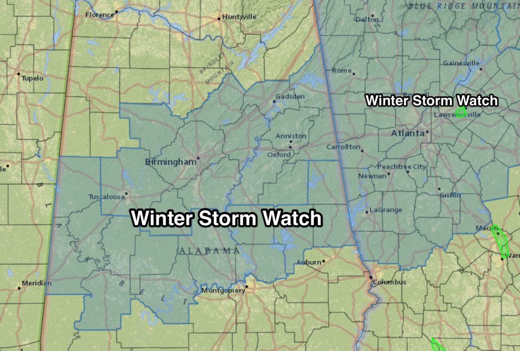
PREVIOUSLY REPORTED – TRUSSVILLE –The National Weather Service in Birmingham has issued a winter storm watch beginning at 6 a.m. Friday through 9 a.m. Saturday. The watch for thirteen counties in central Alabama includes Jefferson, St. Clair and Blount.
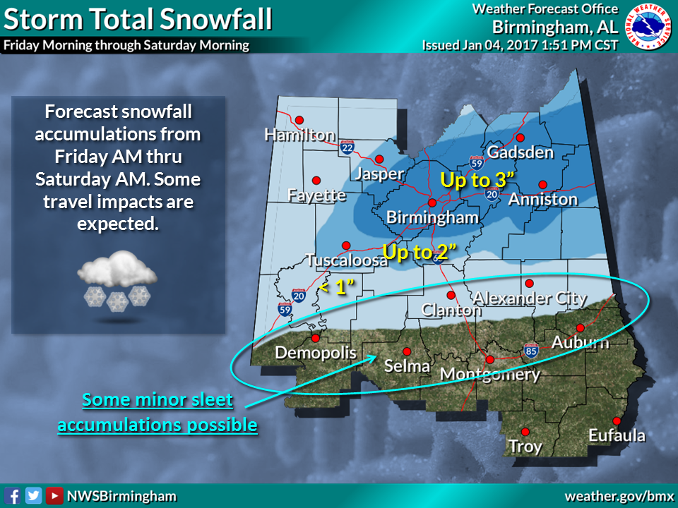
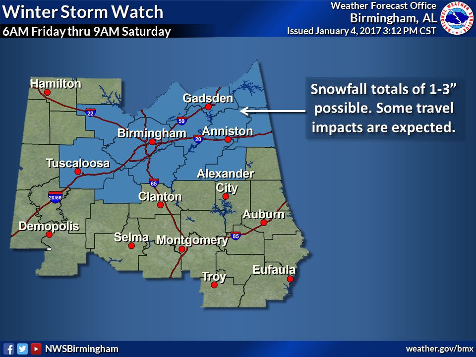 According to the NWS, a strong cold front will dive southward on Friday morning plunging temperatures near or below freezing. At the same time, a weak gulf system will begin spreading moisture northward into the watch area Friday morning through Saturday morning. This could result in accumulating sleet as the system exits northward.
The largest impacts will be along the I-59 and I-20 corridor. Sleet could accumulate as far south as I-65. Up to two inches of snow accumulation are possible between I-59 and I-20 from the metro Birmingham area east and northeastward. Accumulations of less than two inches are possible west and northwest of metro Birmingham.


19 Comments
Sabrina Millwee Meeks
Kimberly Allison I hate not knowing what we need to do about work.
Sabrina Millwee Meeks
Kimberly Allison I hate not knowing what we need to do about work.
Michael Nichols
Carrie Nichols Michael Nichols
Kalean Miller
Heather Hudson
Kimberly Allison
I agree completely!! I am not getting stuck at the clinic again
Carrie Nichols
Sherri Bradford
Jessie Odell
As I’ve said
Many times in my life two
Inches isn’t anything to get excited over….
Michael Deck
Were in the up to 3 inch category now Shea Deck
Sherri Bradford
Good thing I live in shelby county
Chuck Biddinger
Anything less then 3″ is a waste.
Susan Christine Beard
I will believe it when I see it
Holleigh Reid Piersol
Tawanda Lakia Swain maybe you were right
Mark Notz
We are getting the same storm tonight into tomorrow. I think you may get more than we will. Hmmm.
Lynda Shelton
Clay Shelton
Brittany Bearden Farley
Ain’t nothing going to happen
Katie Nelson
WOO HOO. BRING IT ON!!!
Phillip Cottle
The Weather Channel is saying only a dusting of maybe a 1/2 inch for Birmingham as of 5 a.m. this morning.
The Trussville Tribune
Per James Spann- 6:23 a.m. Thursday – “Euro model ensemble mean showing about 1.4” of snow for Birmingham by tomorrow night.”
Kathy Torbert Maylon
Drew Maylon